Useful information, especially if you're traveling to Cambria from the San Francisco Bay Area (page 1 of 2)
If you only want to read the local information, click to go to Page 2.
San Jose to Cambria, in General
San Jose to Cambria is almost exactly 200 miles and 3 hours if you drive at the speed limit. (An extra 5mph shaves 15 minutes off the trip.) The distance from San Jose to Cambria is almost exactly the same as that to San Luis Obispo, so the mileage signs for SLO along Highway 101 work well.
The 85/101 Merge
Traffic is always slow at the 85/101 merge; get to the leftmost lane early, because the merge loses the right two lanes. In addition, the two long southbound hill climbs tend to slow and bunch up the traffic. Things don't really loosen up till you get to Morgan Hill. After Gilroy the traffic gets even lighter.
If you're traveling on a weekday, make the effort to get past the 85/101 merge area by about 3pm if possible. (At 3pm the carpool lane is enforced, so keep that in mind too.) Once you're past this point, the traffic keeps thinning out as you go south.
Salinas
Salinas to Cambria is almost exactly two hours if you do about 75mph on 101 (see the warning about King City below.)
Soledad
The long, straight bridge at Soledad (over the Salinas River) is almost exactly halfway between San Jose and Cambria, at the 100-mile point.
King City
You enter King City on a very long, S-curved bridge over the Salinas River (again!). King City, about 110 miles south of San Jose, is the home of a CHP training center. Keep your speed at or below 70 while approaching the city. A few minutes past Greenfield is a good place to back off.
The 70mph Zone
At the south end of King City, the speed limit goes up to 70mph for 40 miles. Don't be tempted to floor it just yet: wait a few minutes till you pass the truck stop at Wildhorse Road. Sometimes the CHP will wait at that on-ramp. When you're safely past Wildhorse and there's no sign of CHP, then you can push it up to 75; some drivers go right on up to 80..
A few minutes south of Wildhorse Road you cross the Salinas River...again.
Camp Roberts
Camp Roberts, a large California National Guard camp (and a WWII Army training camp before that), occupies most of the 70mph zone. When you get to the spot with all the buildings (many are in disrepair, some dating back to WWII), you've just crossed the line from Monterey to San Luis Obispo county.
Special thanks to Sgt David B. Medzyk, USANG, who provided some info on the recent uses of Camp Roberts:
Camp Roberts is known as "the most active, inactive post in the world!" True, while many of the barracks and chapels are in total disrepair — at least the ones seen from highway 101 — 3/4 of the cantonment area has been rebuilt and repaired and is in year 'round use by all branches of the military, not just the National Guard. The Airfield is active, as well as the drop zones for airborne operations. We have active tank and howitzer ranges, along with new rifle, pistol and machine gun ranges. We have just built a 1000yd sniper range for the Special Forces and Rangers to practice on, after they parachute into camp.
The Navy regularly flies practice bombing runs onto the impact area, and the Pt. Hueneme SEABEES are a common sight. US Marines use our facilities for combat vehicle training, and the Navy SEALS can be seen using the Nacimiento river for their training.
As for the National Guard, units from the western US use the post often, as we have the good fortune of being far away from any heavy populations and are able to fire the largest artillery pieces in the inventory. Camp Roberts is the home training ground for the 40th Infantry Division, well known and respected from deeds and exploits during WWII and Korea (the 40th was the command that re-took the Phillippines, and was the instrumental force behind the breakout from the "Punchbowl" and Heartbreak Ridge campaigns in Korea).
Camp Roberts is currently undergoing selective destruction of unused and decrepit buildings and facilities. We will slowly change the face of the post into a more modern training area, and open up areas for civilian usage. For the complete story of Camp "Bob", come on by the museum. Mr. Davis has built the museum into a wonderful storyboard of history and artifacts.
The East Garrison is home to the Manuever And Training Equipment Site (MATES), where all heavy assets of the 40th Infantry Division are maintained, stored and issued out to the battalions for training. There are over 200 M1A1 Abrams Tanks; more than 100 155mm self propelled howitzers; nearly 100 M2A2 Infantry Fighting Vehicles; over 400 more tracked combat and support vehicles; almost 400 heavy truck and wheeled vehicles and well over 2000 small arms, mortars and 25mm automatic cannon (I work in the Armament shop and maintain all the weapons systems). Some of this warfighting capability is noticed every summer, as large multiple explosions can be heard and felt as far away as Atascadero!
|
The first time you make the trip, Camp Roberts seems to go on forever. Enjoy the wide open spaces, the oak trees, and the occasional grazing cattle or sheep. If you're good, you might spot an old chapel on the camp property.
The Rest Area
There's a rest area within the Camp Roberts section of the trip, about five miles before you cross into San Luis Obispo county. At that point, you're 48 miles – about 45 minutes – from Cambria.
Paso Robles
Paso Robles, a city of about 30000, straddles Highway 101. As in King City, you enter the town on a long, curving bridge, but this one doesn't cross a river — it just crosses Spring Street and the Amtrak tracks. Not quite as spectacular as the one at King City.
Highway 46 To The Coast
At the south end of Paso Robles, take the exit for Highway 46 west to Cambria/Hearst Castle–a very scenic drive. The road is posted at 55, and I always stay about 63 or below. Beware that CHP cruises the road with radar on! The drive from Paso to Cambria takes about 30 minutes.
About halfway to Cambria — where Santa Rosa Creek Road and Old Creek Road cross 46 — there's a mileage sign ("Hiway-1 11; Cambria 15") . Shortly west of this point, there's a great scenic lookout. If the weather is clear, the view is worth a short stop. You can see 20 miles south to Morro Bay (look for the three stacks of the power plant and the 676-foot-high Morro Rock), and north to the Piedras Blancas lighthouse.
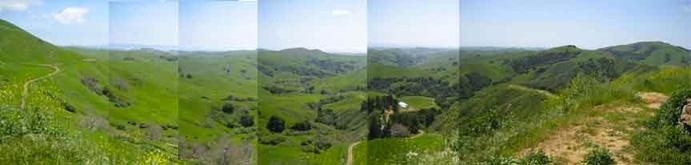 The view south The view south
Follow along onto page 2 for the local Cambria info...
(continued on page 2)
|
|